When Russ said he was in town and keen for a catch up but we both had limitted time we thought a run through this little beauty would be just the ticket and Jason was hell keen too.
It had been nearly 2 years since we first went searching for it and our group was far from the only ones to be inspired by Richard Pattison’s youtube video. Since then it’s be come fairly popular and a track has begun forming through the previously thick scrub. Still we opted for a bit of a scrub bash.
It takes us next to no time to get to the first little abseil.
We slide down this and take what looks to be an obvisous path along a ledge to the left to avoid the next little drop.
Pro tip. Don’t take the obvious ledge to the left. It is muddy, slippery and it’s just causing damage. There’s a much better path to the right of the boulder in the centre of the creek. From above it looks like a drop but when you get to it you’ll see its an easy step down.
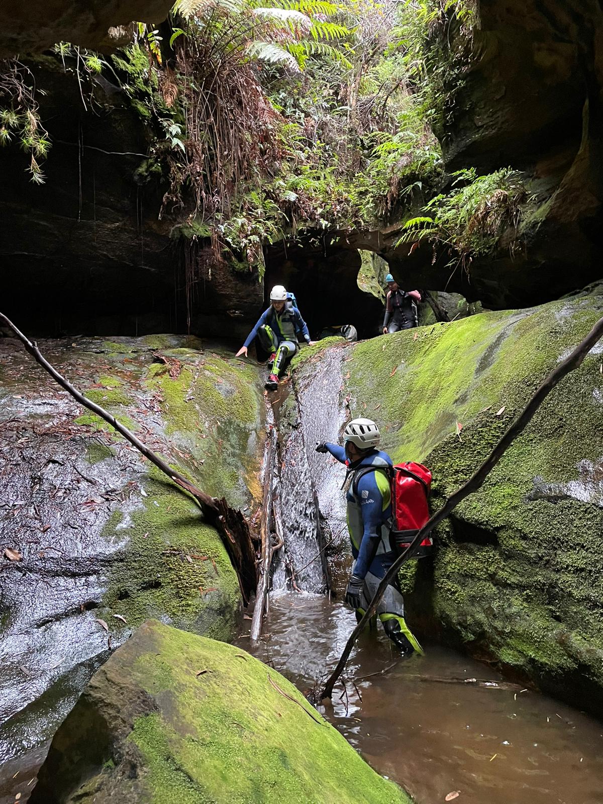
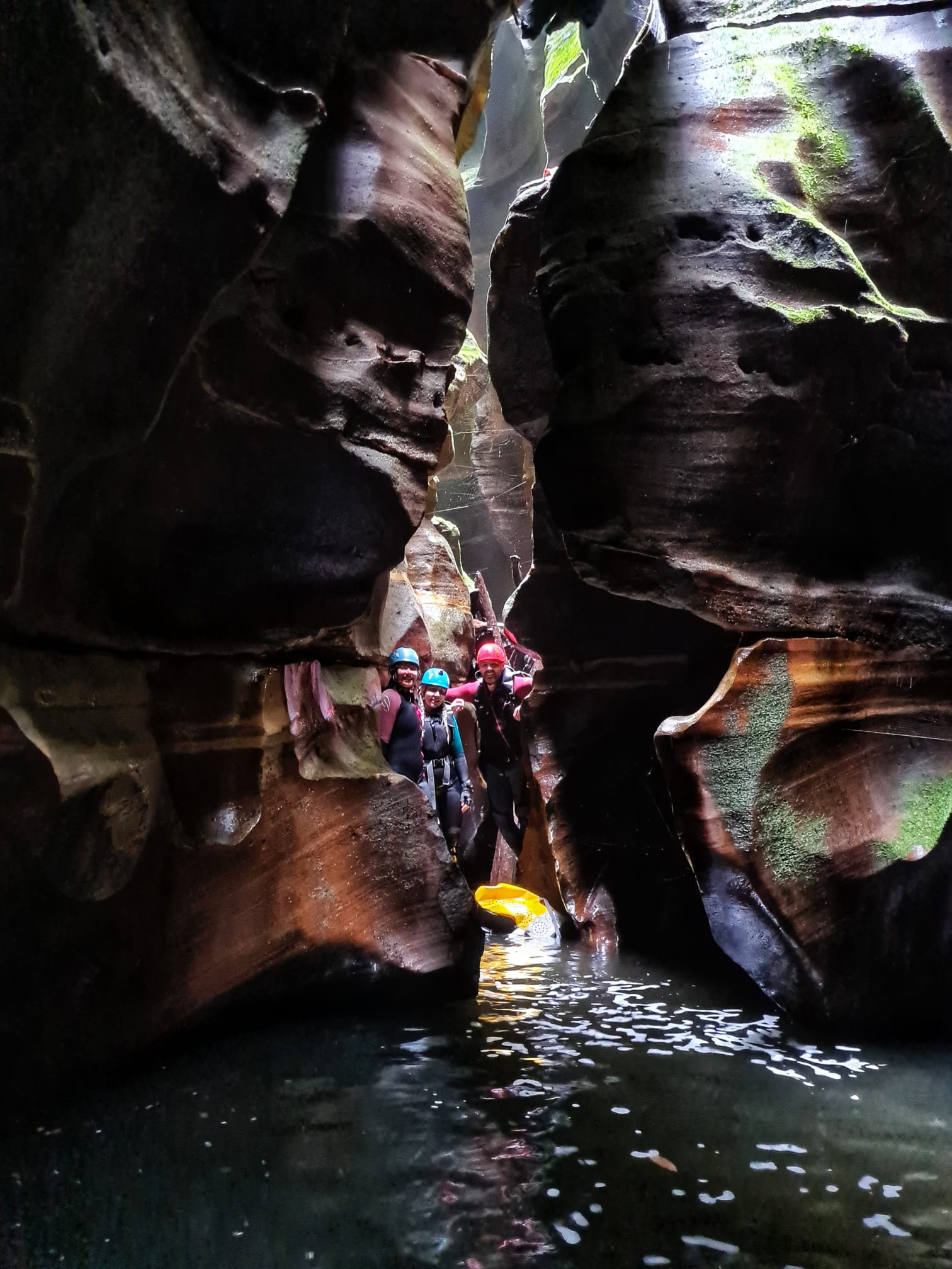
And just like that we are at the top of the drop into the impressive slot.
It’s a lot higher than I remember. Belatedly I am glad we opted to throw in 2 30m ropes “just in case.”
It’s a lot wetter than last time too, which was nice
Russ on rope the 30m ropes just reach aross the pool at the bottom.
A bit of careful foot work see us stay dry above the thighs.
A small down climb brings us to the next abseil with some interesting anchor set up… Last time this was prefect candidate for the fiddle stick. Now sling and rope are in place around the boulder. Make sure you double check these carefully.
Go Go Gadget had been in a moon boot with a broken foot for the last six weeks and now she was out we thought we’d ease back into it.
Or sumfink
We’d thrown around a few options and settled on Serendipity canyon at Mt Wilson. But, um well, Unpopular opinion: I’ve never been a big fan of Serendipity. Just always thought it was overrated. Gadgets wasn’t a fan either.
So we changed plans last minute and headed to a little one off the Bells Line that neither of us had visited before.
Named after an elaborate pot plantation in the head waters that got busted in the 90s I had not given too much thought to Marihuana Canyon before and had low expectations but it was something new so why not.
Scrub bashing down we avoid the upper cliff lines but get to the lower cliff and decide to rope up.
And we shall never speak about the tiny shrubs we used for anchors ever again.
As I use to joke with my old mate Della, if it’s wider than your thumb it’s ok. We never did clarify if you held your thumb vertical or horizontal.
Anyhoo
We enter the creek a little high (see what I did there.)
But it didn’t take long to start getting pretty
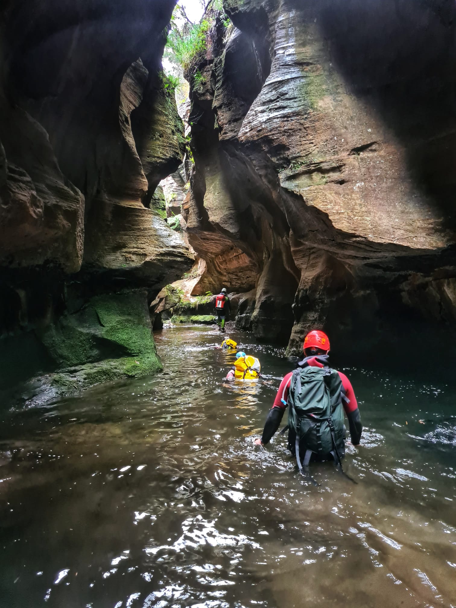
And before long it drops into a stunning little canyon.
The water was so clear.
And soon we reach the junction with South Bowen
We work our way upstream through some very nice canyon section.
A wider section of South Bowen
TBH it was hard work making our way upstream so we got to our exit and hauled out.
He felt that his whole life was some kind of dream and he sometimes wondered whose it was and whether they were enjoying it: D Adam’s
When I first did a trip through the upper middle section of South Bowen creek with Ed I thought it was a spectacular canyon and I’ve been meaning to repeat it ever since.
But, despite having a look through the exquisite upper section I haven’t revisited this section until now.
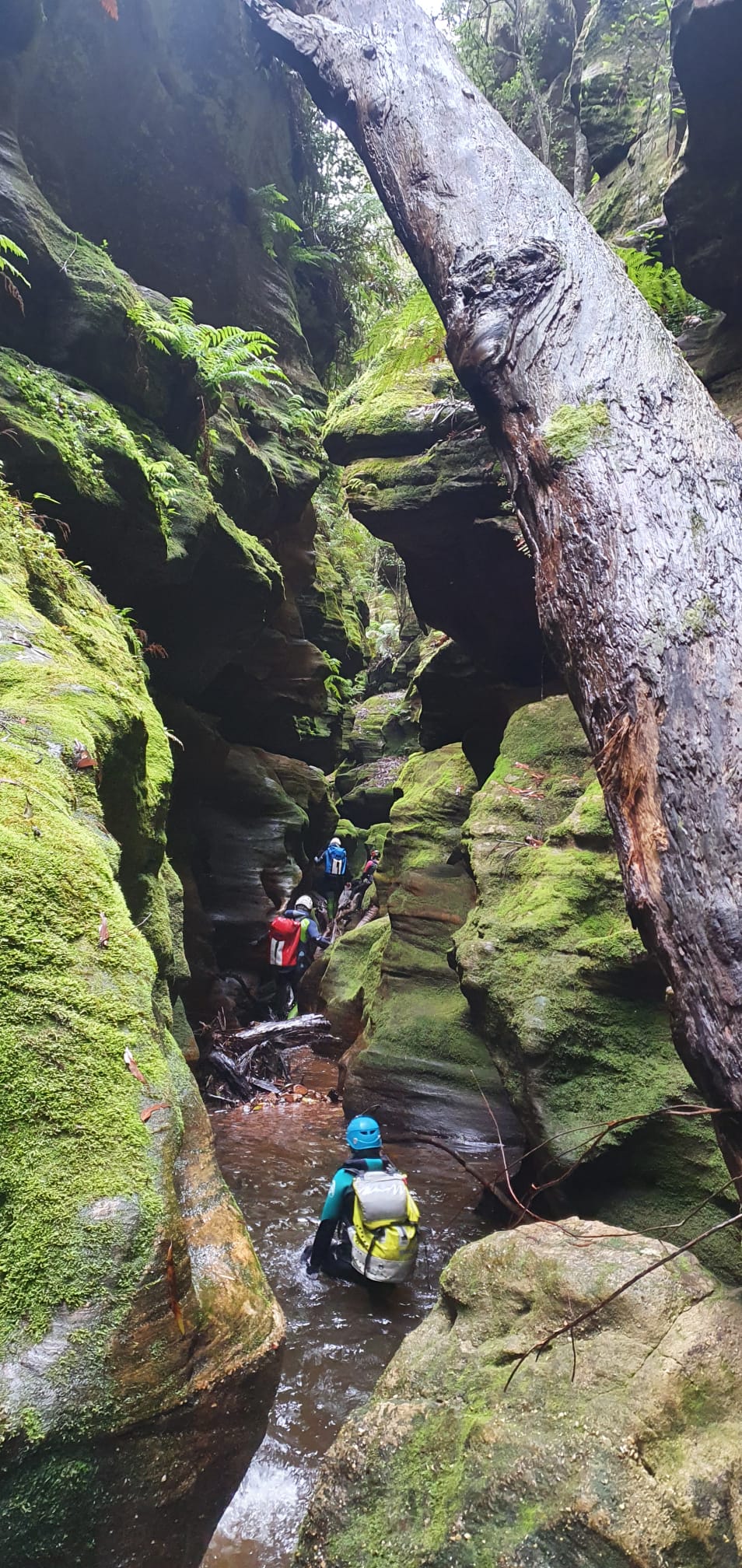
We then make our way down stream. There’s a bit of creek walking down through pleasant coachwood forest before it drops into another dark canyon section.
Jason and Muz making their way down the canyon
The cool misty day made the light sweet
It was every bit as beautiful as I remember but now there’s nothing left to do but to scramble out
So I kinda like visiting the little canyons most people would not bother with.
Part of it is seeing beautiful places most people don’t get to and part is just getting out and exploring with mates.
When Tom posted photos of this one on https://ozultimate.com a few years ago it caught my attention as I had a reasonable knowledge of the canyons in that area but didn’t recognise this at all.
Then a month or so ago a YouTube video was posted that had a few clues.
10mins of comparing images in the video and the areal images on sixmaps and I was confident I knew how to find the start and how to get out.
Anyhoo it had been so long since I’d dragged friends out on a scrub bash to a low quality canyon that they had forgotten the pain and agreed to come again.
Was it scruby? Yes it was
Was it low quality?
The canyon section was pretty. Pretty short. But actually pretty.
Wetsuits were over kill. I thought there might be a bit more flow in the falls after last weeks rain but most of us stayed dry above the knees.
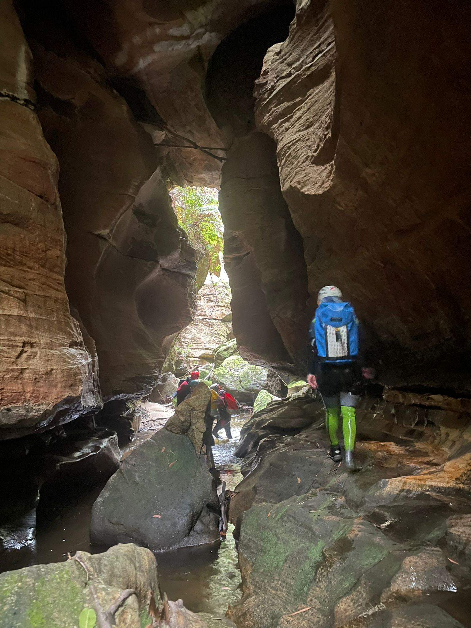
Just a few abseils and a short hallway and the canyon opened up
Then it was back up the ridge and we avoided some of the scrub back to the car
A bit under 2.5hrs car to car with a large group and giving Muz some abseiling refreshers along the way.
It’s been a while since I’ve organised an obscure trip.
Others take the piss out of my scrub bashes to shit canyons but I get a kick out of checking out places the majority wouldn’t bother with.
So when we were thinking about what to do and South Bowen formed up as the front runner I suggest how about we go in fro the top.
Not that’s it’s overly obscure, for as long as I can remember David Noble has been commenting that people miss 3 or 4 canyon sections by going in the “standard” entry.
Still upper sections tend to be hit and miss so I wasn’t expecting high quality but they are all worth doing once.
The only hitch was the car shuffle. We didn’t have a second car.
Let’s just do the top and scramble out the Cork Screw entrance. Says I. That way it’s only a 2km walk back up the highway and we can do that first.
Deal.
We pick one of the branches below Mt Wilson turn off and make our way in. It was scrubby on the spur and muddy in the creek line.
Like scrubby scrub and muddy mud
But it’s only a short bash to the first canyon section. And it’s surprisingly high quality.
And once we got to the junction with the “standard” entry we reversed back up the Cork Screw section and found a break in the cliffs to scramble up.
Kylie, Hywaida, Kris, Jason, Aimee, Tash and meeeeeeeeee
19/02/2022
I’ve done the lower section of Bell creek a couple of times. It’s beautiful.
Like really, jaw droppingly beautiful
But the first time it took us 3hrs to walk into the start of the access canyon, Bell Fry(which is a pretty little canyon in its own right)
Next time we knew where we were going and a hazard burn had taken out a lot of the scrub on the ridge. So we cut that down to just under 2hrs.
But it was still a difficult walk, having to scramble into the start of Du Faurs creek then climb up the other side.
Anyhoo, the Jamieson guide says a good overnight trip is to include the upper section. It also suggests you could do both in a very very long day.
Myself and Madie had mentioned a few times about having a crack of doing it in a day. But we never got around to it
This year a trip got planned. Unfortunately last minute I had to work
I get a text. Ok we are heading in.
Just over 6hrs later. We are out.
Wait! What?
Anyhoo I finally got the chance to give it a crack.
Now I’m not as quick as Madie and Russ but a 30min walk down a fairly easy ridge, with me just following my nose until Aimee checked the map and corrected my course and we slipped down a short side canyon and entered Bell creek just upstream of where it canyons up.
I’ve said before that Du Faurs creek is a more canyony version of the Wollangambe. Bell creek is even more so.
We wade scramble and float down some long, impressive canyon sections @kylie
So the girls hadn’t caught up for a while and there was a chatter. Well, I say chatter but it was more weird noises and giggling. And, I say giggling, but it was more like cackling. Like b grade movie witches planning downfalls.
TBH I wasn’t expecting the upper section to be so good.
“Upper sections” as described in the book can be hit and miss around here. The upper section of Du Faurs creek is good. The Bowens (North and South) have upper sections that contain pretty canyon sections but they pop in and out and there is scrub and scrambling between. Upper Wollangambe is basically a creek walk…. But this one has sustained sections of quality canyon.
Ok so there are no abseils… I get that’s what some people are after but it’s like 2 totally different sports. Vertical canyoning and this.
Maybe the old skool bushwalkers had it right when they described these trips as Swalks (Swim/walks)
either way it’s an adventure in beautiful surrounds with great people. Winning
Because I knew it wasn’t the very very long day Jamieson suggested we weren’t rushing at all. We even stopped for little lunch… I never stop of little lunch… but we still managed get from the car to the junction with Bell Fry in just a bit over 3.5hrs. So not much longer than the standard way into the lower section and far more interesting.
The gate keeper to the lower section
As surprisingly nice as the upper section is the lower section really is special
It might not be as iconic as the Hulks Fist in Claustral but its the Hulks Hand
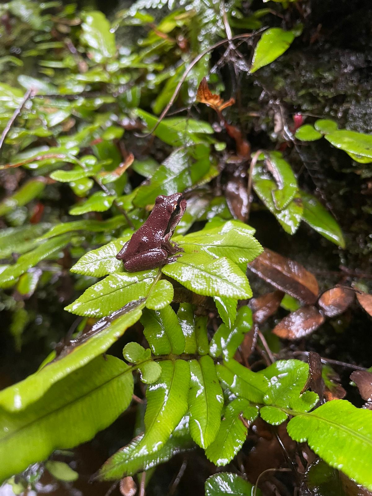
We stop for a bite to eat and Kris finds this little beauty
Hatchling Eastern Small Eyed snake. It was teeny tiny
And then the Canyon opens out a bit. It’s still grand and dwarfs us as we boulder hop down to the junction with Du Faurs creek. Then up to exit out Joes and up to the fire shed.
Group Size: 7
Time: 8.5hr car (Water Trough Hill) to car (Fire Shed).
Some of God’s children just are naturally wild: Ray Wylie Hubbard
Sleepy little town on the outskirts of the Riverina
A small sleeper of a canyon somewhat less visited than it’s neighbours
The name fits with other creek names in the area. Yileen = To dream/dream like. Dalpura = Peaceful, Kamarah = Sleep. I’ve not been able to find a meaning for Koombanda, Jungaburra or Jinki but assume they fit the theme somehow.
Like most canyons in this area it’s not that deep or sustained but has some pretty bits to it.
From the bottom of Koombanda it’s possible to scramble up the nose below the junction and drop back down into the top of Kamarah. I guess this is the way most people do it, it makes sense as they are both short and adding in Kamarah then exiting up to the west via convenient tree roots can be a quicker than exiting via the old mine, especially if you don’t want to do a car shuffle.
You do, however miss some nice erosion caves further up the gully
Anyhoo this description is almost longer than the canyon already
With a day off and everyone else seemingly busy I took the opportunity of a quick afternoon stroll. The creek is drier than I’ve seen it before. I wander down off the ridge, check out the caves which seem to have a lot more block fall than I remember, then make my way down until the walls start to canyon up
The water level is down at least 30cm from my last visit
But it’s still a lush green in contrast to the burnt out ridge lines nearby
First drop is about 3m, some careful bridging meant I could keep my feet dry today
You can see how far down the water level is from usual
More shallow canyon follows
Then the creek drops into a dark hole
Typical of canyons in this area it has one, shallow but stunning chamber
And some nice bits follow
And then just before the junction with Koombanda brook you can climb out on the right, or continue down this this nice overhang to scramble up on the left
Time: 2.5hr car to car with a lot of faffing around
Whatever you do today don’t forget to be just that tiny little bit awesome