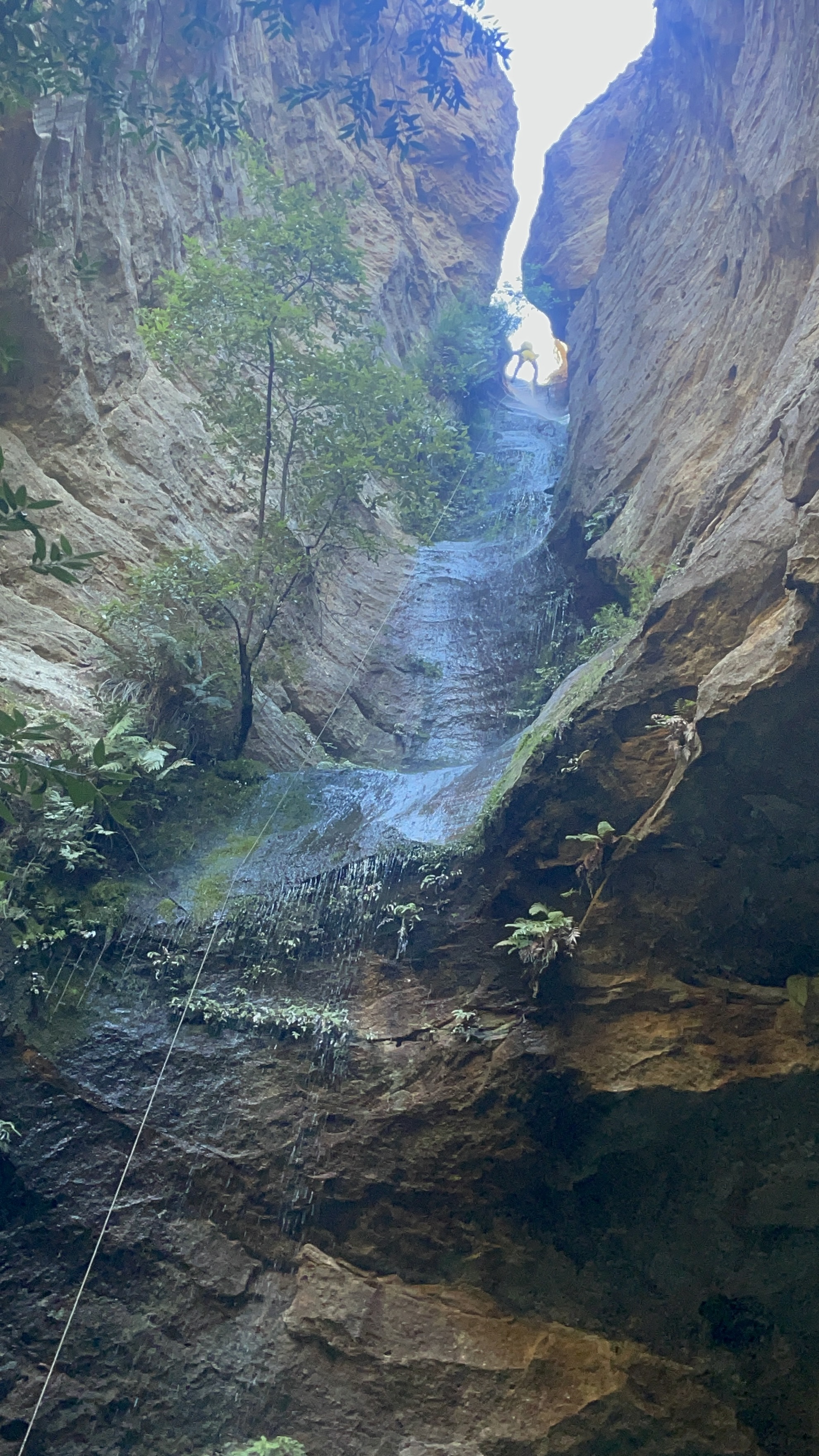
Great Uncle George canyon fell out of favour for a bit.
A change of land ownership saw the start of the Ingar fire trail locked up but also restricted access for canyoners to the quickest way in.
The alternate route in was a scrub bash that made an average quality canyon barely worth the effort.
But then top bloke and local legend, Blue Philips stepped up to the plate, contacted the owner and, convinced the him to trial allowing canyoners access across his land.
The conditions are explained by Blue
“ Permission this time from the owner (now sometime resident), Warren, stipulation is: keep as far left as you can, away from the house/environs, once you walk around the locked gate/fence, head down near the two abandoned caravans to the lower gate, close it behind you, locate first abseil (slings on tree), and off you go. We’re effectively ‘on trial’, so as long as no-one’s a flog and spoils our access privileges, GUG is back on, via the easiest and simplest ingress route. If you see someone else acting suspiciously, call them out, the owner has endured a lot of negative stuff over the years; bushrock theft, building material theft, motorcycle hoons hooning, fires, drugs, you name it. Us canyoners need to be as pure as the driven snow:-)”
Anyhoo we thought why not take advantage of Blues hard work.
Retracing the entry I’d used years ago with Julie and the Cooks, it took no time to get to the start.
And before long we were at the exit point that cuts back up to the Areoplane Hills picnic area.
We stop for lunch then scramble up onto the ridge. From there it’s an easy stroll up the ridge, made easier from a hazard reduction burn earlier in the year that has cleared out the scrub
GUG might not be the most exiting canyon but finding a patch of wilderness close to suburbia has a vibe all of its own.
When Surveyor General Mitchell was making his map of NSW he asked his surveyors to, where possible, use the traditional place names.
(When he wasn’t naming stuff after Macquarie, that is)
His map had the northern branch of this creek system marked as Bungleboori Creek. Clew’s 1930’s Military Survey had the branchs labled “Bungleboori 9 mile” and “Bungleboori 12 mile”. They later became known as Bungleboori North and Bungleboori South.
This suggests it was a mistake when the Geograffic Naming Board renamed the Northern Branch to the rather less evocative “Dingo” Creek.
While tame camp dogs were called Dinggu by the Dharug people of the upper mountains, and thats where we get the term Dingo, wild dogs would have been more commonly called Warragal by the Dharug and Wiradjuri.
The Gundungurra may have used that term too. So why Dingo Creek?
Anyhoo that is nether here nor there as we are headed for the southern branch, now officially “The” Bungleboori creek.
This was a very last mintue decision. After a couple of hectic weeks we opted for (what we thought woud be) a slightly less committing trip.
I hadn’t done Arthurs before, nor Hailstorm Retreat for that matter, and Kylie hadn’t done many canyons in this section of the Bungleboori at all.
We had a quick puruse the the maps the night before and decided that was the plan.
the bright eyed anticipation of adventure
The road out to Waratah ridge is rough as guts at the moment. It’s the roughest I’ve seen it since the 2002 fires. If you are heading out that way a car with high clearance is recommended.
the wild flowers though…
We head up the usual track but soon spear off on a side trail.
I was expecting an old 4WD trail out to views and this matched my expectation though the trail looked more well used than I thought it would be.
And there I was blindly following the trail down into a gully when Kylie called, Hey this isn’t right. We should still be on a ridge.
She has an uncanny ability to map out a route and picture it in her head.
We stop to look at the map. This was our first time using lidar overlays, courtesy of Rob’s Maps, they are an awesome tool. Thanks Rob H for creating such a wonderful resource.
Yep! we shoud be on the ridge and, if anything, dropping off the other side. We debate heading back up the trail or dive off and traverse across.
If we traverse the topoline aroud the top of that gully it’s only 150m across and half the elevation. Argue I.
Gadget reluctantly agrees, loath to dive into the scrub this early on what is sure to be a scrub bash.
But I’m the the scrub master, usually. Little did I know.
Back on course we follow the ridge until near the end then opted to descend a creek line. I’d read the gully wasn’t too bad….
Let’s just say we should have got out of the creek line early and looked for a nose. The scrub along the creek was horrendous. Anyone who has been on one of my infamous scrubbashes knows that’s a big call.
It was a relief when we popped out of the bushes onto a very pretty section of Paddys…. I mean the Bungleboori.
then, steadfastly avoiding anything that slightly resembled a creek line, we pop up the nose on the other side and with a couple of short scrambles break the first major cliff line suprisingly easily. We traverse down to cross a creek line then, again easily up the nose to break through the upper cliff even easier. Its rare I find the up 10x easier than the down whch just goes to show how bad the scrub in the creek was.
We are now at the base of the Mini Arthurs.
We have a decision. Gadget had mapped out a route that skirted around the outcrops and dropped into the creek closer to where Arthurs was meant to drop into a canyon however that meant missing weaving through the maze of the Arthurs themselves and potentially missing the upper section.
We weave up through the Arthurs and into another scrubby creek.
This one isn’t as scrubby as the previous (yet) and we soon reach a scramble into a very tight slot. Its jammed full of sticks but I clear them out as I work my way in. 1 very tight squeeze and it opens back up. Just downstream it drops into another short squeeze to what looks to be an abseil but this is so jammed full of debris we were forced to retreat up and around the next side gully.
And here’s where the scrub decided to step up a notch or ten.
On a scale of 1 to 10 how bad was it?
to use a 30 year old meme
Holy cutty spikie grabby shit fight batman.
At times I couldn’t even tell if we were in the creek or on the bank or what. Even heading up the slope onto what should have been a spur between two creek lines offered no relief.
Finally we came to a spot where the creek bagan to drop through boulders. and a slot of sorts openned before us.
It’s not much to look at so far.
but just downstream we are surprised
The creek twists down through a pretty waterfall into a stunning chamber.
With care the pools could be avoided but by this stage Kylie had no cares left to give and opted to frolick in all of them with reckless abandon.
And just like that it opens up.
Kylie didn’t agree with me but I did say if that canyon section was in the middle of Claustral it would be the nicest 20metres of Claustral. Maybe the 5hrs of dense scrub bashing had me delusional but certainly not delutional enough to ever want to come back. Arthurs is defiately a oncer.
OK, “best bit of Claustral” is probaby a stretch. Maybe Grand. If it was in the middle of Grand it would be the best 20 meters of Grand.
But we still had more dense scrub to bash through down to the junction with the ‘Boori. then a further engery zapping boulder hop down to where we would camp for the night.
We got the tarp set up just as the storm hit. And hit it did.
As my mate Russ would say it pissed it down.
Interestingly the creek didn’t rise that much with the storm but come morning we watched it rise about 50mm in 20min while we ate breakfast. The lag effects of water running down tributaries and soaking through the ground was cool to see.
We were pretty beat up from the previous day (and hadn’t done any big trips recently so a little off our canyoning game fitness) The temperture had also dropped over night, I think we had forgotten how cold the ground stayed at this time of year and only bringing our summer kit was optimistic. So we opted to have a lazy start then exit out rather than forging through another day and camping again.
From our camp down to our exit the Bungleboori was much more forgiving. Boulder scrambles were mostly avoided with easy walking on the banks and the couple of deep wades actually felt good as the water took the load of our packs.
Smiling again. for now
and then it was up.
Steeply up.
Scrubby up.
And into Hailstorm retreat.
Doesn’t look like much to start but its a pleasant slot that carves all the way to the top of the upper cliff line.
And from there its a relatively easy stroll over the tops to the Waratah ridge track and the monotonous trudge back along the fire trail.
Hang on, where’s that. Exclaims I to myself like a mad man.
I’d been playing Richard Pattison’s ‘What canyon is that’ game and trying to pin point one of his Beyond the Guidebook canyons on the map. I’d dicyphered the clues pretty quickly and added a waypoint to my map. Then I got side tracked as often happens.
Flicking through canyon reports and looking at maps my gaze had drifted to a different canyon area altogether when I came across a refference to another canyon along th Bells Line that I hadn’t done.
There wasn’t much info to go off but we thought why the hell not go for a look. We weren’t expecting much, the satelite imagery wasn’t overly exciting so I figured it would a creek bash with abseils but it fit our need for a shorter day.
We parked up where we thought the exit woud be, hoofed back up the road a bit and then bashed our down through a bit of razor grass and native raspberry before finding a dry water course that got us through the worst of the scrub before we travsered a bit further upstream to where I’d marked an possible entry.
H found a break in the lower cliffs and we scrambled down with the aid of a hand line.
The pretty creek matched what we were expecting
Just downstream though it dropped into a proper little canyon.
The double drop looked to have a deep pool in the midshelf so we scrambled out and travesed to a tree, hoping to descend straight to the lower level and avoid getting too wet.
From here it’s a pleasant walk down to the gully we opted to exit out.
.
We could have continued down to a more popular walk and exit a couple of kilometres downstream but we opted to punch up to the cliffline and follow a narrow ledge up to a break where, with a short climb (one or 2 grade 8 moves) we gained the nose and it was an easy stroll back up to the road.
And we finished the day with a ride and picnic. Why not
When Russ said he was in town and keen for a catch up but we both had limitted time we thought a run through this little beauty would be just the ticket and Jason was hell keen too.
It had been nearly 2 years since we first went searching for it and our group was far from the only ones to be inspired by Richard Pattison’s youtube video. Since then it’s be come fairly popular and a track has begun forming through the previously thick scrub. Still we opted for a bit of a scrub bash.
It takes us next to no time to get to the first little abseil.
We slide down this and take what looks to be an obvisous path along a ledge to the left to avoid the next little drop.
Pro tip. Don’t take the obvious ledge to the left. It is muddy, slippery and it’s just causing damage. There’s a much better path to the right of the boulder in the centre of the creek. From above it looks like a drop but when you get to it you’ll see its an easy step down.
And just like that we are at the top of the drop into the impressive slot.
It’s a lot higher than I remember. Belatedly I am glad we opted to throw in 2 30m ropes “just in case.”
It’s a lot wetter than last time too, which was nice
Russ on rope the 30m ropes just reach aross the pool at the bottom.
A bit of careful foot work see us stay dry above the thighs.
A small down climb brings us to the next abseil with some interesting anchor set up… Last time this was prefect candidate for the fiddle stick. Now sling and rope are in place around the boulder. Make sure you double check these carefully.
The Pool of Aphrodite is a well published spot in the Gardens of Stone that doesn’t get lot of traffic due to it being a bit of a scrub bash to get to.
Yuri referred to it as the Heaven pool (Thanks Matt M for that info) but Keats officially named it Pool of Aphrodite with the geographical naming board.
When they published it in the Gardens of Stone Guides people would bash their way around from the more popular Pool of Diana, But it was a long, leg slashing slog.
A while ago I punched a more direct pass down through the cliffs oposite it but got foiled with a last little cliff I didn’t have rope for.
Anyhoo a few weeks ago Gadget and I had a rare spare afternoon and as she hadn’t been to the North Bungleboori Arch we thought why not go for a quick look at that and then pop over the ridge to see if we could make it down to Aphrodite.
The Arch is spectacular.
We scramble down to the bottom of the arch and phaff around with the camera for a bit before heading back up to drive a bit further down the road to see if we could work our way down to the Pool of Aphrodite.
We get down to the cliff edge with a fantastic view to the slot that hides both the pool and the waterfall that feeds it. But for the life of me I couldn’t find the break in the cliff had got me so close many years ago
Kylie pulls out the topo and studies it momentarily. I reckon theres a pass upstream on the other side that will get us there, says she.
We slip back up to the car and drive around the head of the gully.
Her pass was a winner and before long we are at the pool.
It’s barely shin deep, a little underwhelming as far as pools go. But it’s a pretty spot.
Looking up at the slot cutting through the towering cliffs above we agree it would make an amazing abseil. The satelite image suggested there might be a small slot above it.
Keats describes it as being fed by a 30m waterfall. It’s a lot higher than that.
We file it on our list of things to do when we have nothing to do.
Which brings us to today. We had a big overnighter planned but circumstances lead to it being canceled and suddenly we had nothing to do.
And on top of the things to do when we have nothing to do list… that abseil.
A last minute, late night invite was thrown out to see if anyone else would like to join us and to our delight both Ed and Hywaida were keen.
We were expecting it to be a short trip so it was close to 11am when we roll into our car park.
It’s a 600m bash down the ridge, skirting the swamp until a pinch in the cliffs force us into the thickests of scrubs.
Ed resorts to his tried and tested method. Turn, use his pack a a shield and throw himself backwards into the wall of vegetation.
I’ve missed scrub bashing with Ed.
In no time he had bulldozed us a path to the top of the falls.
Unfortunitely there’s no slot above them. Also more scrub and a slippery slope is preventing us from getting a good look at the drop.
We slip up the pagoda next to it to get a view over the impressive slot dropping into the pool somewhere below.
A loooooong somewhere below.
It’s a substancial cliff and the best anchor tree is a long way back from the edge We start to wonder if our ropes are long enough.
We decide to set up and send the first abseiler to the edge to get a better look.
Belatedly I realise I’m the first abseiler!
I’m not scared.
Honest.
Ensuring I have my ascenders at the ready I get on our 75m rope and work my way down to the edge. It’s set as single strand with the 60m attached to the other end in case they need to lower me further.
I can see the pool, calls I.
It’s an impressive if somewhat intimidating drop.
Does the rope reach? Call they
I can’t see, there’s a slope to an overhang then maybe a ledge. I’m going to head down to see.
Living up to Aphrodite’s name its a lovely, beautiful, and pleasurable abseil.
Alternating between steep, near verticle slabs and long overhangs.
And the 75m reachs with about 6 or 7m to spare.
The top of the slot feels like it wraps around and encloses you before funneling out. After 5 days of drizzle there is enough flow that you can’t really get out of the spray. Prefect on a late Autumn day.
And just like that we are all down.
All that’s left now is the traverse around to the exit gully and a quick punch back up to the road.
wild_elly, dw3lla, freedom_runs, mshbee, estonian_pirate and meeeeeeeeeeee
Most people visit Thunder Canyon from the bottom, wandering up from the junction after absieling in from Claustral or Ranon.
After all you get to visit the best bit while also doing another of the Classic 3. The tops not worth it. Said they.
By they are all worth doing once say I.
We’d actually planned this several times. Once we canned it because Gadget and H couldn’t make it.
Then they canned it because I couldn’t make it.
Then we canned it because Jason couldn’t make it.
And we all but canned it this time because Kris and Muz were going to a running race.
But the race fell through so at the last minute Thunder was back in business. Baby!
We head out along the ridge with a couple of options of where we might drop in.
Stupidly I ignored my own advice about wearing long pants in favour of lighter weight and more room in the keg. This meant by the end of the walk in I’d have a bit less skin to carry out too…
About mid ridge we gain a rocky outcrop. The views were stunning and the walking a lot less cutty.
We have more scrub to push through but it’s not as bad from here out.
Finally we get to a spot we think we should drop in so as not to miss a short uppersection of canyon. We follow a minor tributary down hoping it offers an easy break but it cliffs out much too high for our ropes.
We push back out and gain a small nose that leads down, down, down, cliff out.
At least there are ledges below us that have decent trees to reanchor from. Still we seem to be a long way up.
We set a rope and I absiel down and spend a stupidily long time looking for options to get us into the creek. Problem is I can see another ledge below but still can’t tell how far down the creek is. It sounds like a fair cascade or waterfall below.
I have the irrational thought that we are directly above Westaway Falls. The eap shows them a fair bit down stream but I’m second guessing.
I call Jason down for back up. He shares concern about the water echoing below and whether we are missing a good bit of canyon. I show him a couple of options including one a little up stream.
I can see the creek bed there. Says he. He has better eye sight than me but I make out the rocky creek bed amid the dark shadows.
Come on down we call.
We get everyone down to the ledge and Kristo leads the abseil to the Canyon.
Oh Wow this looks like the start of Empress. he calls.
We’d gotten our entry spot on at the start of a short but pretty section, that as Kristo said, had the start of Empress Canyon vibes.
We make our way down stream. some tricky ledge walking and spidermaning keeps us dry for the time being.
The canyon opens a bit and we make our way down a pretty gorge. There’s some scrambling, wading and downclimbs. Basic good fun.
I have the anchor, calls Kris from down canyon right.
But there is an awesome looking slot up here. Calls Jason from back abit canyon right. We check out the slot. It looks great and jason is super keen to drop in but Kris has already set rope. Wait til you see this abseil thou, He calls.
We head down. He is right this abseil looks amazeballs.
Of course this means we’ll need to do a second trip to do the slot option.
Kylie fishing for glowworms
Ms H Bee dropping in
once down…
Glowworms behind waterfalls
While I have visited this section many times from below it always blows me away and coming in from the top was just a bit extra special .
And before long we come to the Claustral Junction. From here down the canyon is well known to all of us and the rest of the trii is prettt cruzy
Remember just like it takes 7 wipes to know for sure you only needed 6, you need to do the canyon yourself to know whether it’s worth it.
They are all worth doing once and I’d definately repeat this one.
After Devils Pinch and Starlight we opted for a lazy Easter morning then a quick trip through Pipeline canyon.
Kylie wasn’t feeling well so decided to sit out.
The rest of us retraced yesterdays steps up the Pipeline trail but speared off early into the side canyon I’ve always known as Drainpipe.
I’m sure I’ve used an easier way into Drainpipe with Tim that avoids all the scrub in the upper gully, but as with last time with Russ we bashed down the gully.
Jess and Wisie were on rope duties and had their work cut out as some of the anchors needed creative solutions. A few of the anchor trees were rotten or completely gone.
Drainpipe lives up to it’s name with trickling skanky sludge rather than water.
will Brooke avoid the sludge?
negative.
A few tricky abseils later and we reach the junction with Pipeline.
The water will be crystal clear from here, says I
I should not of said that.
We get to the first large drop and down I go.
There’s a very dead kangaroo wedged into the corner of the pool below oozing its essence into the atmosphere.
</Spewie face>
Emerging from the Roo Stew pool
The log slide
Making our way down the narrow canyon
And before we know it we pop out of the canyon on the last 2 abseils.
After a bite to eat we follow the base of the clifflines back to the Pipeline track passing this little cutie along the way.
“There is pleasure in the pathless woods, there is rapture in the lonely shore, there is society where none intrudes, by the deep sea, and music in its roar.” — Lord Byron
Some of my earliest memories are of 4wding and camping with my dad in the Wolgan Valley.
The valley has a Genius loci.
A sense of place.
An allure.
It’s history of occupation, both Aboriginal and European, hangs in the air and hides in the undergrowth.
It’s special.
I remember times when it was less known, camping far down the river on unexpected flats.
I remember the hight of popularity when you had to get there early (On the Thursday or even Wednesday prior) to get a good spot on a long weekend.
And I remember more recent trips, where the restricted access returned a feeling of being almost alone in the valley.
So when an old footy mate offered to let me camp on his block of land hidden deep up a gully rarely travelled by the masses I jumped at the chance.
It’s Easter weekend, we wont be alone in the valley. Many campers were utelising Thomas’s shuttle, cabins and camp facitlities at Newnes Cabins. A few more walked in and set up in the NP camp ground (Why they still require bookings and charge fees when it’s walk in only is beyond me).
The road up to our campsite was rough and overgrown in parts but passable. The old hut was no longer there, another casualty of the Gospers Mountain fires, but the block itself every bit as beautiful as always.
We could have been a million miles from anyone, anywhere, and anywhen.
We are up and on the trail early. The pass up via the Pipeline trail is straightforward and Kylie leads us out along the ridge top that separate Newnes from Glen Davis. There’s a good trail for much of the way but as we near the top of Devils pinch creek we veer off, taking a short cut over a knoll and down into the creek.
H leads us down the creek to the first drop, there’s nothing really indicating the deep chasm to come.
We bypass the first few scrambling drops, favouring the longer drop off the ledge to the right.
I set the rope and Kylie leads the way in.
I’d forgotten how spectacular the top section of Devils Pinch is.
Gagdet remarks it’s second to Crikey in feels of depth and narrowness.
The second abseil comes straightway and has a very tricky start but Gadget is on anchor duty and guides us down no dramas.
Brooke regales us with a song.
Just around the corner the deep channel is filled with light
The canyon walls open out and we make our way down to the lower constriction.
Some scrambling and careful bridging keeps us out of the manky water, mostly.
And soon we come to the 20m abseil into the drier lower hallway.
As the canyon opens out we pause for lunch, then dump our canyon gear and make our way along the base of the cliff for a couple of hundred meters to the bottom of Starlight Canyon.
While worth doing on it’s own from the top I think combining it with Devils Pinch in this way makes it a great day out.
We reverse up the canyon, there’s a couple of scrambles but nothing overly tricky, unless you decide to try an alternative squeeze up a chute rather than the easy climb up and along the tree roots like I did…
The bottom of Starlight is like a hidden world and you half expect triceratops to be grazing on the fernery.
And then the canyon closes in.
I get the camera gear out and send the others ahead.
Just a hint of what’s to come
A young eastern brown snake. Pseudonnaja (meaning “Fake cobra”) Textilis ( meaning “scales like my wife’s stockings”).
And soon the walls close in futher and all light is lost
Well not all light.
Your description of a tunnel section severely under sold this. They say when the meet up halfway through as they were coming back down. “Cavern” would be more appropriate.
Over head bats chittered and fluttered.
But we need to head back to the light.
It’s just the way we do it.
We follow the cliffs back around to the bags then make our way down to the river and back to camp.
“Because when you stop and look around, this life is pretty amazing.” — Dr. Seuss